
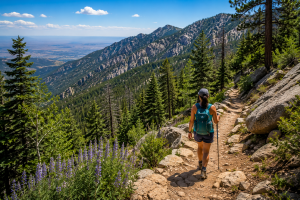
Albuquerque proper sits at 5,312 feet, which is already a meaningfully cooler starting point than most Southwestern desert cities — but on a genuine July heat day, even that elevation isn’t enough. The Sandia and Manzano Mountains east of the city solve the problem the way mountains always do: gain elevation, and the temperature drops with you. A trailhead at 7,000 feet running through ponderosa pine forest is a fundamentally different thermal environment than the valley floor, and the East Mountains give Albuquerque-area hikers genuine relief within a short drive.
The Elevation Math: Why These Mountains Actually Cool You Down
Using the standard atmospheric lapse rate of approximately 3.5°F per 1,000 feet of elevation gain, a trailhead at 7,000 feet runs roughly 6 to 7°F cooler than Albuquerque’s valley floor at 5,312 feet on a comparable day. Push higher — to the 9,000 to 10,000-foot range near Sandia Crest — and the temperature difference reaches 13 to 16°F below the valley floor. On a 98°F Albuquerque day, that’s genuinely comfortable hiking weather at altitude, and it’s the specific reason locals treat the Sandias and Manzanos as their summer heat escape rather than avoiding hiking altogether during triple-digit stretches.
The forest cover adds a second cooling layer beyond elevation alone. The Sandias transition through multiple life zones as elevation increases — piñon-juniper woodland at lower elevations giving way to ponderosa pine forest around 7,000 feet, and eventually mixed conifer and subalpine fir approaching the crest. That canopy cover provides genuine shade that the exposed high desert around Albuquerque doesn’t have, compounding the elevation-based temperature drop with actual sun protection.
“Once you’re up in the ponderosa pines around 7,000 feet, the character of the day changes completely. It’s not just cooler — the light is different, filtered through the canopy, and there’s a smell to a pine forest after a summer rain that the desert floor just doesn’t have. It feels like a genuinely different place, twenty minutes from downtown Albuquerque.”
Sandia Mountains: Trail Options by Elevation and Effort
La Luz Trail: The Serious Elevation Gain
La Luz Trail is the Sandias’ signature challenging hike — approximately 8 miles one-way with 3,775 feet of elevation gain at a demanding 12 percent grade, climbing to either Sandia Crest or the Sandia Peak Tramway’s upper terminal at 10,378 feet. The trail crosses four distinct climatic life zones on its way up, giving hikers a genuine ecological transect in a single day’s climb. This is a serious undertaking, not a casual summer stroll — but for fit hikers looking for a real physical challenge with a payoff of cool mountaintop air and expansive views over Albuquerque, the cinder cones of the Albuquerque volcanic field, and Mount Taylor in the distance, La Luz delivers. Starting at first light is essential in summer, both for the heat at the lower elevations and to avoid afternoon monsoon thunderstorm risk near the exposed upper sections.
Crest Trail Segments: Shorter, High-Elevation Walks
For hikers who want the cool high-elevation air without La Luz’s demanding full ascent, several shorter Crest Trail segments accessed from the top (via the Sandia Peak Tramway or a drive up the Sandia Crest Scenic Byway) give genuine high-altitude hiking without the climb. The segment from Sandia Crest to the historic Kiwanis Cabin — a stone shelter built by the CCC in the 1930s — is approximately 1 mile with modest elevation change, offering an easy, high-elevation walk with substantial payoff for minimal effort. Segments toward the Upper Tram Terminal offer similar short, high-altitude options with sweeping views of Albuquerque and northern New Mexico.
Tijeras Canyon Area Trails: The Easy Access Option
For hikers based in the East Mountains near Tijeras, the Sandia Ranger Station area offers accessible, lower-commitment trail options that don’t require the drive up to the Crest. The Tijeras Pueblo Archaeological Site interpretive trail, beginning behind the Sandia Ranger Station, winds past interpretive signage describing the 14th-century Tijeras Pueblo — a short, easy, educational walk suitable for any fitness level or age. The Cedro Creek trail, with a numbered-signpost brochure available at the Ranger Station, offers a similarly accessible nature walk in the same immediate area. Both are genuinely easy options for a morning outing that doesn’t demand serious elevation gain or technical trail navigation.
Manzano Mountains: The Quieter Southern Range
South of I-40, the Manzano Mountains continue the same Sandia-Manzano geologic formation but with a distinctly different character — less crowded than the more famous Sandias, with a quieter, more forested feel that appeals to hikers who want the elevation and shade benefits without the higher foot traffic that popular Sandia trails like La Luz attract on summer weekends.
Manzano Mountains State Park and the surrounding Cibola National Forest trail network offer hiking through similar ponderosa pine and mixed conifer forest terrain, with the added draw of fall aspen color later in the season and consistently good birding throughout summer, given the range’s position along a significant raptor migration corridor. For hikers specifically seeking a quieter alternative to the sometimes-crowded Sandia trails during peak summer weekends, the Manzanos are the practical answer within a similar drive time from the Albuquerque and East Mountains area.
Practical Summer Hiking Tips for the Sandias and Manzanos
Start early. This is the single most important practice for comfortable and safe summer hiking at any elevation in these ranges — not just for the heat at lower trailhead elevations, but specifically because of New Mexico’s summer monsoon pattern. Afternoon thunderstorm development, common from early July through mid-September, brings lightning risk that’s particularly dangerous on exposed ridgelines and near the Crest. Planning to be off any exposed high-elevation section by early afternoon is standard practice among experienced New Mexico hikers, not overcaution.
Bring more water than feels necessary — the dry air and elevation gain both increase dehydration risk beyond what hikers from humid climates typically expect, even when the air temperature feels comfortable. Sun protection remains necessary even in forested sections, as New Mexico’s elevation and clear skies produce stronger UV exposure than equivalent latitudes at sea level. Proper footwear matters particularly on the rockier, exposed sections of trails like La Luz, where loose gravel and steep switchbacks present real footing challenges.
Elevation cooling: ~3.5°F per 1,000 ft gained. 7,000 ft trailhead ≈ 6-7°F cooler than Albuquerque (5,312 ft). Near Sandia Crest (10,678 ft) ≈ 13-16°F cooler.
La Luz Trail: 8 mi one-way, 3,775 ft gain, 12% grade. Strenuous. Start at first light. Four life zones crossed.
Crest Trail segments (from the top): Crest to Kiwanis Cabin ~1 mi, easy, historic CCC shelter. Short high-elevation options with minimal climbing.
Tijeras Canyon trails: Tijeras Pueblo Archaeological Site interpretive trail and Cedro Creek trail — easy, family-friendly, near Sandia Ranger Station.
Manzano Mountains: quieter alternative south of I-40, similar elevation/forest cooling benefit, less crowded than popular Sandia trails.
Monsoon safety: afternoon thunderstorms common July-September. Be off exposed ridgelines by early afternoon. Check current access at friendsofthesandias.org before a Crest-area hike.
For the full picture of East Mountains and Albuquerque area hiking and outdoor recreation, the Albuquerque and East Mountains exploration guide covers the broader activity calendar beyond these specific trails. The New Mexico RV travel and planning guide gives the routing context for combining a Sandia/Manzano hiking stop with a broader New Mexico trip. For travelers continuing north toward Santa Fe after a Sandia hiking day, the RV park in Santa Fe, NM page covers that option. And for planning any East Mountains stay with summer hiking in mind, Albuquerque RV Park is the starting point.
Frequently Asked Questions
How much cooler are the Sandia Mountains than Albuquerque in summer?
Using the standard atmospheric lapse rate of approximately 3.5°F per 1,000 feet of elevation gain, a trailhead at 7,000 feet in the Sandia Mountains runs roughly 6 to 7°F cooler than Albuquerque’s valley floor at 5,312 feet on a comparable day. Near Sandia Crest at 10,678 feet, the temperature difference reaches approximately 13 to 16°F below the valley floor. Combined with the shade provided by ponderosa pine and mixed conifer forest at higher elevations, the felt temperature difference on a hot summer day is often even more pronounced than the raw air temperature difference alone, making the Sandias and Manzanos a genuinely effective heat escape from Albuquerque summer conditions.
What is the best easy hike in the Sandia Mountains for summer?
For an easy, low-commitment summer hike, the Crest Trail segment from Sandia Crest to the historic Kiwanis Cabin is approximately 1 mile with modest elevation change, accessible via the Sandia Peak Tramway or a drive up the Sandia Crest Scenic Byway, offering high-elevation cool air and views with minimal physical effort. For an easy, family-friendly option near Tijeras, the Tijeras Pueblo Archaeological Site interpretive trail, beginning behind the Sandia Ranger Station, is a short educational walk with numbered interpretive signage describing the 14th-century Tijeras Pueblo. The nearby Cedro Creek trail offers a similar easy nature walk in the same area. Both Tijeras-area options avoid the demanding elevation gain of trails like La Luz while still providing a pleasant outdoor experience.
How difficult is the La Luz Trail?
La Luz Trail is a strenuous hike — approximately 8 miles one-way with 3,775 feet of elevation gain at a demanding 12 percent average grade, climbing from the western base of the Sandia Mountains to either Sandia Crest or the Sandia Peak Tramway’s upper terminal at 10,378 feet. The trail crosses four distinct climatic life zones during the ascent and includes rocky, exposed sections with loose gravel that require sturdy footwear and careful footing, particularly on the descent. This is not a casual hike — it typically takes experienced hikers 5 to 8 hours round trip depending on fitness level and whether a one-way tram descent is used. Starting at first light is strongly recommended in summer, both to avoid peak heat at lower elevations and to be off the exposed upper sections before afternoon monsoon thunderstorm risk develops.
Are the Manzano Mountains less crowded than the Sandias?
Yes, generally. The Manzano Mountains, located south of I-40 and connected to the Sandias through the smaller Manzanito subrange, see meaningfully less foot traffic than popular Sandia trails like La Luz, particularly on summer weekends. The Manzanos offer similar elevation-based cooling and forest cover benefits — ponderosa pine and mixed conifer terrain within the same Cibola National Forest system — but with a quieter, more secluded feel. Manzano Mountains State Park and the surrounding forest trail network are good options for hikers specifically looking to avoid the crowds that concentrate on the most popular Sandia routes during peak summer hiking season.
Is it safe to hike in the Sandia Mountains during monsoon season?
Hiking in the Sandia and Manzano Mountains during New Mexico’s summer monsoon season (roughly early July through mid-September) requires specific timing awareness due to afternoon thunderstorm development, which brings genuine lightning risk on exposed ridgelines and near Sandia Crest. The standard safety practice among experienced New Mexico hikers is starting early and planning to be off any exposed high-elevation section by early afternoon, before typical thunderstorm development begins. Checking the day’s specific weather forecast before departure, watching for building cumulus clouds during the hike, and having a clear turnaround plan if conditions deteriorate are all standard precautions. Trails with substantial forest cover at lower-to-mid elevations carry somewhat less lightning exposure than fully exposed ridgeline sections near the Crest.
Is the Sandia Crest area currently open for hiking?
The Sandia Crest recreation area has experienced periods of closure related to infrastructure work, with some reports indicating certain facility closures extending into 2027. Trail access and specific facility availability can change, so confirming current conditions before planning a Crest-area hike is essential. The most reliable sources for current access information are Friends of the Sandia Mountains (friendsofthesandias.org) and the USDA Forest Service’s Cibola National Forest Sandia Ranger District, both of which post current trail and facility status. Lower-elevation trail options in the Sandias and the Manzano Mountains to the south are generally less affected by Crest-specific closures and remain reliable alternatives if Crest access is limited during your visit.